|
| Squeezing through reed beds |
There are Arthur, Roland and me… just three of us pushing into the
westerly breeze across Lake Malaren toward the island Bjorko. Once in shelter
we sneak up the eastern side through reed beds beside dense woodland to
approach our landing in the northeast. Maybe we’ll have wind at our back for
the return.
Two tour boats and a number of small sailboats cluster
around the sheltered harbor Angholmen. The island looks sleepy. But maybe as
long ago as 3,500 years ago the island was used by Bronze Age hunters. There
are nine Bronze Age burial cairns at the south end, but what’s better known is that
during the 8th and 9th century AD there was a bustling Viking
market town here; an important trading center.
 |
| These lake islands have dense woodland to the shore |
We change from our paddling gear, fire up a stove in the
shelter of a tree and make espresso. After lunch we go exploring. First there’s
a small museum that shows a lot about the town as it would have been, with an
amazing model of the village and fortifications. That’s useful to get an idea
of the layout, because much of what remains is below ground, covered by a skin
of turf. It’s also an opportunity to see replicas of relics found here, and
examples of building techniques.
What we can see is a high outcrop of rock inside the hill
fort, Borg. From the top of the rock is an impressive view across the lake and
islands.
 |
| Wide view from the Viking hill fort Borg |
 |
| We explore the ramparts of the Viking fort |
Outside the distant rampart surrounding the town site is a
graveyard, “Hemlanden” (homeland). It’s the largest of its age in Scandinavia
and holds some 1,600 graves in the form of barrows, stone ships and stone
circles. The island holds more than 3,000 such graves.
So many graves indicate what a large population center Birka
became at that time. Starting in the early 800’s as a trading center, it first
traded with south-west Europe, but later switched to trade mostly with the
east, with such places as Tashkent and Samarkand. Trade is a two-way process,
so goods manufactured in Birka, such as the characteristic oval brooches worn
by women, have been found in graves in Russia, while Islamic and Byzantine
coins have been found at Birka, along with remnants of other trade goods.
 |
| Small Viking boats wait in the reeds |
We visit a group of reconstructed houses and garden plots In
a small bay on low land that in Viking days would have been below sea level.
This hamlet is used both by historians to learn about the building methods used
back then, and to educate visitors. Nestled in the reeds nearby against a
narrow wooden dock are a few small Viking boats. Adding color to the scene are
small groups of people “living the Viking life” dressed in historically correct
clothing, cooking over fires and carrying out what would likely have been daily
tasks back then. This realistic play-acting reminds me how little things change
through the centuries. Many people around the world still live in much this
way.
 |
| Viking building methods were used in these reconstructions |
We walk the island, between the mounds of the ancient
burials, and around the defensive ramparts that once were fortified with wooden
walls and towers. It’s easy to imagine the attraction of this site when it was
inhabited, but what happened to the population when it declined as a town?
 |
| More than 3,000 Viking burial mounds have been found here |
 |
| Stockholm sits where the lake meets the sea |
 |
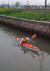
| Point65's Richard Ohman approaches the lock in Stockholm |
Now Stockholm guards the entrance to Lake Malaren and its locks allow boats to drop smoothly from the lake on average 0.7 meters to sea level. The land is still rising, though less slowly now, at a rate of about 1 cm per year.
 |
| Evening, the lake side of the lock |
More about Birka